One of the fundamentals of any spatial project is establishing a coordinate system to describe the data. This coordinate system allows us to pass our data along to another person and they are able to understand it, or enter the data into a computer system to process the data.
A coordinate system is described by an origin, the orientation of three axes, and the parameters of which describe the position. (Krakiwsky and Wells, 1971)
 The origin of a system is an arbitrary point of which all measurements will be in relation to, this point is often a stable, non-moving, point at the center or corner of the measurements. The origin must be a clearly defined point so that it maybe related to other coordinate systems, for example, we describe the origin of a geocentric system as being the center of mass of the earth.
 Often the next part of the coordinate system we describe is the tertiary axis. In most topocentric terrestrial coordinate systems we define this as being inline with the plumb-line, i.e. the direction of gravity at that point, at the point of origin with the positive direction being in the zenith direction though it could run in the nadir direction. In some cases it is to our advantage to define the axis in terms of a primary pole which is an axis of symmetry for the system. Often for geocentric systems we assign the primary pole as the spin axis of the earth.
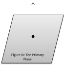 After the tertiary axis is defined we may set the primary plane as a plane that contains the origin and is perpendicular to the tertiary axis. Often for geocentric systems the primary plane is often the equator. Contained within the primary plane is the primary axis, and the secondary axis.
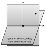 We can establish the primary axis through defining a secondary plane which is a plane that is perpendicular to the primary plane and contains the origin as well as another point, whether it be of interest or an arbitrary point. The intersection of the primary and secondary planes is then the primary axis with the values running positive in the direction of the defining point, this axis is also sometimes referred to as the secondary pole. For most earth systems Greenwich, UK, is the arbitrary point used to define the secondary plane.
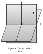 The secondary axis is then defined as a line that runs perpendicular to the primary and tertiary axes. The direction of this axis is defined by the right/left-handed orientation. Figure (V) uses the left-handed rule.
The parameters that describe a system will be covered more in-depth in a later post.
References/Further Reading:
Great Britain. (1965). Admiralty manual of Hydrographic Surveying. London. England: Hydrographer of the Navy. Vol I
Krakiwsky, E. J., & Wells (1971). Coordinate Systems in Geodesy. Fredericton, N.B: Dept. of Surveying Engineering, University of New Brunswick.
Vaníček, P., & Krakiwsky, E. J. (1986). Geodesy: the concepts. Amsterdam: North Holland.
